1. Introduction
here are 56 reservoirs in the Republic of Uzbekistan with the volume of about 20 billion m3 of water filled from the Amu Darya, Syr Darya, Zeravshan, Chirchik, Surkhandarya, Naryn, Karadarya rivers and 28 large irrigation channels with flow rates of more than 100 m3/s diverting water from these rivers. In this regard, it is very important to determine the amount of sediment in water sources to calculate the volume of channel cleaning from sediment, as well as to calculate the volume of filling the reservoir with sediment, i.e. the useful volume.
In the channels of watercourses, sediments are transported in a suspended state, distributed throughout the living cross-section of the stream and bottom sediments, moved in the bottom layer [1][2][3][4][5][6][7][8][9][10].To determine the amount of suspended sediment in the stream, samples are taken at hydrometric stations, and their concentration is determined in the laboratory by various methods [11][12][13][14][15][16][17][18][19].Measuring the flow rate of bottom sediments in nature is much more difficult than measuring the flow rate of suspended sediments.
Due to the complexity of direct measurement, many researchers propose to determine the flow rate of bottom sediments by a very approximate ratio between suspended and bottom sediments. For example, S.T. Altunin [20] recommends taking the flow rate of bottom sediments of the rivers of Central Asia based on the following percentages of the flow rate of suspended sediments: in mountainous areas -15-23%, in foothill-5-15% and on the plains-1-3%. A. G. Khachatryan [21] and H. S. Shapiro [22] suggest that for the conditions of the Amu Darya, the flow of bottom sediments is equal to 10-11% of the flow of suspended sediments. V.E. Tuzov [23] expresses the opinion that the share of bottom sediment runoff varies both along the length of the river and in each section, depending on the water content of the year. For a high-water year, the flow rate of bottom sediments in the Tuyamuyun formation is recommended to be equal to 18% of the flow rate of suspended sediments, and for a low-water year, even 33%. This approach to determining the flow rate of bottom sediments is very approximate and uncertain.
A.I. Turaev and other researchers [24] determined the flow rate of bottom sediments of the Amu Darya by the volume of deformations or by the movement velocity of bottom sand ridges. Based on the data obtained, they established the percentage ratio of bottom and suspended sediment discharge for different sections of the Amu Darya River in different periods of the year. For example, for the target at the beginning of the water intake section of the Amu Bukhara Machine Canal (ABMC), the flow rate of bottom sediments is: when the flood rises (April-May) -from 3.5 to 75% of the suspended flow rate; in the flood (June-July) -from 2.0 to 19%, when the flood falls (August -September) -from 3.7 to 32.5 %. For the lines located below the ABMC, the bottom sediment consumption is 2.5-21.4 % of the corresponding suspended sediment consumption. Repeated measurement work on the Amu Darya with the calculation of the volume of channel deformations allowed V.E. Tuzov to derive a formula for calculating the flow rate of bottom sediments, which has become generally accepted: II.
2. Materials and Methods
The construction of water intake and reservoir nodes on rivers with an eroded channel violates the natural regime of their liquid and solid runoff. As a result of the backwater created by the nodes, a significant part of the river sediments is retained in their upper stream, and the clarified stream discharged through the culverts of the dam into the lower stream is gradually saturated with sediments due to deep and planned deformations.
The purpose of field studies is a preliminary forecast of the solid runoff flow rate, taking into account the moving ridge forms and changes in the turbidity of the Amu Darya River. The object of research is the alluvial regime and riverbed processes in the section of the Amu Darya riverbed with the length of 20 km below the Tuyamuyun hydraulic engineering complex. The beginning of the section was section 2, located 900 m below the spillway dam of the hydraulic engineering complex, and the end was section 64, located 4 km below the Tashsakadamless spillway node.
The channel of the Amu Darya River at the research site is composed of disjointed fine-sanded soils, the products of erosion of which in the form of bottom sediments are moved by a stream in the form of sand ridges. The movement of ridge forms was studied by visual observations. During the observations, the planned movements of the skewed ridge located in the section 64 were recorded. The ridge velocity was 18.3 m/day. This velocity should be considered overestimated, since the natural movement of the ridge was disrupted by the dredging operations carried out: a hole was dug in the riverbed to artificially change the direction of the current, the head of which was located at the distance of 200-250m from the crest of the observed ridge. The sharp increase in the slope of the water surface caused by digging led to an increase in the ridge movement velocity. In addition, since the section 64 is located at the distance of 3-4 km below the head regulator of the Tashsaka, as a result of water intake into the channel, the water consumption in the section 64 decreased, and the average size of sediment in it increased due to the intensive entrainment of the smallest particles of sediment into the regulator. For these reasons, the ridge formed in the section 64 did not correspond to the hydraulic regime of the flowing flow.
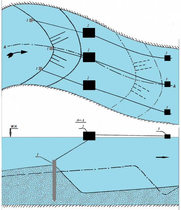
Similar observations were made for a skewed ridge in section 40, located 9.3 km downstream of the dam. The flow rate of water in the line is equal to the flow rate of releases to the lower stream. The horseshoeshaped crest of the skewed ridge occupied the entire width of the riverbed. The tongue of the ridge was located at a distance of 1/38 from the left bank. The small turbidity of the water in the river made it possible to clearly distinguish the position of the ridge crest on the bottom up to a certain depth of the stream. At great depths of the stream, the outline of the ridge crest was traced by the pronounced difference in the free surface of the water, which was distinguished on this surface by an oblique dark line.
In the course of visual observations from the boat, not only the planned position of the ridge crest in the riverbed was determined, but also the ridge height was measured at 11 characteristic points. To determine the ridge movement velocity at these points of its crest, metal pegs with the length of 80 cm were fixed or a heavy load was placed. Then two floats were attached to the fixed points, connected by the 20 m long cord, one of which showed the position of the ridge at the initial moment of time, and the other -the direction of ridge movement and the water flow. The figure 1 shows the schematic plan for placing floats on the ridge crest under study. After fixing the time of setting the floats exactly after 1-3 days, the position of the ridge crest was measured in relation to the floats showing the initial position of the ridge, and based on changes in this position, the length of the path of movement of the ridge crest from the point under consideration was determined. The ridge movement velocity was determined by dividing the path length by the time intervals between observations (1-3 days). The ridge height was determined by the difference in the depth of water in its basement and on the ridge. The ridge length was taken as the distance from its crest to the crest of the ridge located downstream or upstream. The distance between the ridges of neighboring ridges was measured as follows: first, the planned outline of the ridge located above the studied one was established, and metal pegs were fixed on it, to which cords 50 m long were tied, ending in floats. After pulling the cords by the current, which showed its direction, metal pegs were installed above the floats, to which the upper ends of the cords were tied, which were untied from the pegs on the crest of the upper ridge. The described procedure was repeated until the crest of the studied ridge was reached.
3. Results and Discussion
The observations showed that the movement of the skewed ridge movement occurs mainly as a result of the movement of secondary smaller ridges on its surface, along the body of which, in turn, even smaller dune ridge forms move. Table 1 shows the average hydraulic characteristics of the flow and soil, as well as the parameters of the main and secondary ridges determined by field studies.
To determine the flow rate of bottom sediments, various measuring devices, calculation dependencies and methods are used. However, to date, there is no generally accepted method. Since the bottom sediments movement occurs in the form of ridge forms in eroded channels, it is easy to calculate the amount of bottom sediment consumption by measuring the parameters of these forms and their movement velocity. The method of measuring ridges parameters was described in the works of a number of researchers [25][26][27][28][29][30]. One of the first analytical expressions of the elementary flow rate of bottom sediments in the ridge form belongs to M.A.Velikanov [31]:
q r = ??h r ?? r ,(1)Here: ? -dimensionless coefficient, depending on the ridge shape and equal to 0.5-0.6; h r and ? r -height and movement velocity of the ridge.
To determine the flow rate of bottom sediments at one of the studied sub-sites, the parameters and ridges velocity were measured using a very unconventional method of visual observations. A small number of measurements did not allow us to establish the connection between the ridges parameters and the flow characteristics. It was difficult to use the existing formulas for calculating the ridges parameters due to the special conditions in the lower reaches of the Tuyamuyun hydraulic engineering complex. Therefore, the preliminary calculation of the flow rate of bottom sediments was carried out on the basis of the initial data of Table 1 according to the formula (1), which was supplemented with the measured values of the ridge height and its movement velocity.
There are three permanent hydrological posts at the research site, where samples are taken to determine the different characteristics of liquid and solid runoff. Data on the amount of suspended sediments were taken from the post "OGMS Tuyamuyun", located 9.3 km below (section 40) of the dam.
4. Calculation Example
1. Consumption of bottom sediments in the ridge form of movement.
5. Data for the calculation:
-Stream width, ? = 542 m; -Soil density, ? =1610 kg/m 3 ; -Ridge height, h r = 1,66 m; -Ridge movement velocity, ? ? = 0.0000162 m/s; -Ridge shape coefficient, ? = 0.55. Thus, during the observed period, the flow rate of bottom sediments moving in the form of bottom ridges was 19.5 % of the flow rate of suspended sediments.
? bot = ??h r ?? r ???? = 0,IV.
6. Conclusions
1. In the lower reaches of the Tuyamuyun hydraulic engineering complex, the bottom sediments movement occurs in the ridge form. 2. With clarified water in the lower reaches of hydraulic engineering units, the geometric and dynamic characteristics and ridges shapes, as well as the process of ridge formation, can be studied by direct observations and measurements. 3. In the riverbed at the research site, the bottom sediments movement occurs in the form of movement of skewed large ridges (mesoforms), along the body of which secondary ridges (riffles) move, in turn, covered with moving dune forms of ridges. 4. The calculation of the solid flow rate, based on the data of direct measurements of the geometric and dynamic parameters of the ridges, and the water turbidity, showed that for the moment of measurement, the flow rate of bottom sediments was 19.5% of the flow rate of suspended sediments.
| S. No. | Flow, sediment, and ridge characteristics | Dimension | Meaning |
| 1 | Water consumption at the time of observations | m 3 /s | 1380 |
| 2 | Streamwidth | m | 542 |
| 3 | Averageflowdepth | m | 2,45 |
| 4 | Averageflowrate | m/s | 1,02 |