1. Introduction
bout a decade ago in September 2004 Hurricane Ivan (see Figures 1 thru 3 and Table1) devastated numerous infrastructures including coastal bridges and offshore oil rigs and damaged or displaced miles of oil and gas pipelines in the northeastern Gulf of Mexico (see, e.g., Panchang and Li, 2006). Measurements of meteorological and oceanographic (met-ocean) conditions near Ivan's track were as follows:
According to Stewart (2004, p.15), wind and gust measurements at 400ft (122m) elevation on an oil rig named Ram Powell VK-956 located near the Ivan's track at 29.05N 88.10W indicated that at 2256Z on 15 September wind speed = 102 knots and wind gust = 135knots. According to the National Data Buoy Center (NDBC), this oil platform (code name as 42364) is very near Buoy 42040 (Fig. 2) (see www.ndbc.noaa.gov), which recorded significant wave height (Hs) = 15.96m and dominant wave period (Tp) = 16.67 second as provided in Table 1. According to Teague et al. (2007), the maximum current speed reaching 2.14 m/s (see Fig. 3) at a direction of almost due west was observed on the shelf in 60m of water at station M1 (see Fig. 2) near the surface (6m). Similar speeds, ranging between 1.73 and 1.96m/s, were found near the surface at the other moorings on the shelf.
Normally, hourly wind speed is employed to estimate waves and currents. However, because the max wind speed measured at Buoy 42040 was only Author: Coastal Studies Institute, Louisiana State University. e-mail: [email protected] 28.2m/s (see Table 1), this wind speed was too low to generate 2m/s current and 16m significant wave height. Therefore, the use of wind speed to estimate waves and currents near the continental shelf could result gross error. The cause may be due to the effects of land mass near the hurricane's landfall and of low anemometer height (at 5m above the sea surface as compared to 16m significant wave height, the effect of wave shadow) on Buoy 42040. Because of these effects, we propose to employ hourly measurements of Hs and Tp instead of using the hourly wind speed. This is the purpose of this investigation.
A
2. Methods
According to Wu (1975),
Usea = 0.55 U* (1)Where Usea is the surface drift velocity, in m/s, and U* is the friction velocity, in m/s.
Analysis of the direct measurements of U* and U10m by sonic anemometry over the North Sea during (2) Since the coefficient of determination (R^2) is 94 percent, meaning that 94% of the variation in U* can be explained by the U10m in this power law formula, therefore, we are confident to use Eq. (2) for our applications. Year 2014
3. E
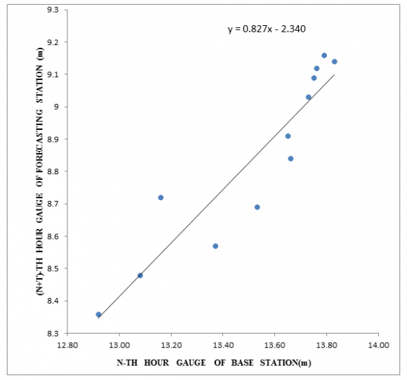
In order to extend Eq. ( 2) into hurricane conditions, Fig. 5 is presented. Because the vorticity method is based on atmospheric physics (Anthes, 1982), it is used here. Since the slope between this method and Eq. ( 2) is near one and that the R^2 value reaches to 94%, we are confident that Eq. ( 2) can be extended into hurricane conditions.
Where g (= 9.8 m/s^2) is the gravitational acceleration, Hs is the significant wave height, Tp is the dominant wave period, and A is the coefficient to be determined in the field during storms. Note that both Hs and Tp are measured by NDBC routinely.
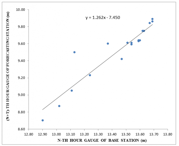
With the data provided in Table 2, we can now compute U* from U10mbased on Eq. ( 2) (except one data point during the hour when the eye of Kate passed over Buoy 42003). Our results are shown in Fig. 6. The coefficient "A" is determined to be 0.052 with R^2 = 0.93 so that Eq.
Now, substituting Equations ( 5) into (1), we have Usea =21 Hs^2/Tp^3 (6)
Eq. ( 6) is our proposed formula to estimate surface currents using wave parameters during a tropical cyclone. on November 20. Note that the coefficient "A" needed in Equation ( 3) is determined to be 0.052 III.
4. Results
Based on aforementioned methodology we can now compute hourly U* and Usea values according to Equations ( 5) and (6), respectively. Our results are listed in the last 2 columns in Table 1. In order to compare with Fig. 3, the time series of Ivan induced drift velocity is also presented in Fig. 7. It can be seen that the comparison is reasonable, particularly the max Usea, which was 2.11m/s. This value is in excellent agreement with that of 2.14m/s as measured by Teague et al. (2007), which is also shown in Fig. 3.
5. Conclusions
On the basis of aforementioned analysis, several conclusions can be drawn:
? Using Hurricane Ivan in 2004 as a case study, it is demonstrated that near surface wind measurements cannot be used to estimate waves and currents.
? A power-law relationship (Eq.2) between the direct measurements of friction velocity (U*) and the wind speed at 10m over the North Sea is found with a coefficient of determination as high as 94%.
? Eq.2 is further supported by the atmospheric vorticity method during Hurricane Inez.
? Applications ofEq.2to the open sea during Katefound that U* = 38 Hs^2/Tp^3, and Usea = 21 Hs^2/Tp^3, where Hs is the significant wave height, Tp is the dominant wave period, and Usea is the wind drift velocity. And,
? Using Eq.5 during Ivan shows that this formula is consistent to the near surface current measurements, particular the peak velocity.

| 12 | 19.3 | 24.2 | 1001.1 | 7.91 | 14.29 | 0.81 | 0.45 | |
| 13 | 18 | 23.3 | 1001.3 | 8.2 | 16.67 | 0.55 | 0.30 | |
| 14 | 19.5 | 24 | 1000.3 | 8.52 | 14.29 | 0.95 | 0.52 | |
| 15 | 22.2 | 28.9 | 997.7 | 9.94 | 14.29 | 1.29 | 0.71 | |
| 16 | 22.2 | 27.6 | 996 | 10.63 | 16.67 | 0.93 | 0.51 | |
| 17 | 23.6 | 29 | 993.5 | 11.74 | 16.67 | 1.13 | 0.62 | |
| 18 | 25.6 | 31.6 | 989.2 | 10.96 | 16.67 | 0.99 | 0.54 | |
| 19 | 25.6 | 31.9 | 985.1 | 12.76 | 16.67 | 1.34 | 0.74 | |
| Year 2014 | 20 21 22 | 27.8 27.9 26.8 | 34.2 37.8 34.2 | 979.9 974.8 969 | 15.25 13.69 14.85 | 16.67 14.29 14.29 | 1.91 2.44 2.87 | 1.05 1.35 1.59 |
| 14 | 23 | 28.2 | 34.9 | 963.1 | 14 | 12.5 | 3.81 | 2.11 |
| 0 | 26.5 | 32.6 | 958.2 | 15.96 | 16.67 | 2.09 | 1.15 | |
| I | ||||||||
| ( ) Volume XIV Issue VI Version E | 1 2 3 4 5 6 7 8 9 10 11 | 25.4 25.4 21.6 26.8 24.5 24.2 21.1 18.9 16.8 16.2 14.7 | 32.9 32.6 29.5 34.2 30.7 29.9 27 23.5 22.7 22.7 18.2 | 956.3 955.3 962 967.6 976 983.6 989.4 992.7 995.5 997.8 999.6 | 14.15 8.72 8.43 7.27 7.45 7.63 7.89 7.22 6.17 5.63 6.14 | 14.29 11.11 10 14.29 10 10 10 10 9.09 10 10 | 2.61 2.11 2.70 0.69 2.11 2.21 2.37 1.98 1.93 1.20 1.43 | 1.44 1.16 1.49 0.38 1.17 1.22 1.31 1.09 1.06 0.67 0.79 |
| Day 0.36 Global Journal of Researches in Engineering Hour WSPD GST BARO Hs, m Tp, sec U*, m/s Usea, m/s 0 12.9 15.3 1008.5 3.45 11.11 0.33 0.18 1 13.4 15.7 1008.4 4.23 11.11 0.50 0.27 2 13.6 16.1 1008.4 4.59 11.11 0.58 0.32 3 13.7 17.1 1008.2 4.98 12.5 0.48 0.27 4 14 17.4 1008.1 5.09 14.29 0.34 0.19 5 13.4 16.2 1007.5 5.83 14.29 0.44 0.24 6 14.5 18.3 1006.6 5.96 14.29 0.46 0.26 7 15.1 19.8 1005.7 6.23 14.29 0.51 0.28 8 15.8 19.6 1004.4 6.93 14.29 0.63 0.35 9 16.5 20 1003.5 7.2 14.29 0.68 0.37 10 17.4 22.1 1002.5 7.47 14.29 0.73 0.40 11 17.6 21.9 1002.2 7.03 14.29 0.64 12 14 17 1001.6 5.66 11.11 0.89 0.49 13 12.5 16.3 1002.8 4.91 11.11 0.67 0.37 14 12.2 15.7 1003.9 4.8 9.09 1.17 0.64 15 11.6 15 1005 4.58 10 0.80 0.44 16 10.6 13.8 1005.8 4.29 10 0.70 0.39 17 10.9 13.4 1006.2 4.46 9.09 1.01 0.56 18 9.6 11.6 1006.7 4 9.09 0.81 0.45 19 8.9 10.4 1006.9 3.54 9.09 0.63 0.35 20 8.9 10.8 1006.4 3.09 7.69 0.80 0.44 21 7.2 8.8 1006.6 2.97 8.33 0.58 0.32 22 7.7 9.9 1007 2.84 8.33 0.53 0.29 23 7.4 9.2 1007.6 2.64 8.33 0.46 0.25 II. | ||||||||
| Day | Hour | Wind direction | U10m,m/s | Gust | Hs,, m | Tp, sec. |
| 18 | 11 | 98 | 9.5 | 10.4 | 1.1 | 6.3 |
| 18 | 12 | 94 | 8.3 | 9.4 | 1.1 | 6.3 |
| 18 | 13 | 91 | 8.7 | 9.9 | 1.2 | 6.7 |
| 18 | 14 | 89 | 9 | 9.9 | 1.3 | 6.7 |
| 18 | 15 | 85 | 9.6 | 10.4 | 1.3 | 6.7 |
| 18 | 16 | 89 | 8.9 | 9.9 | 1.5 | 6.3 |
| 18 | 17 | 84 | 9.2 | 10.4 | 1.5 | 6.3 |
| 18 | 18 | 86 | 9.5 | 10.4 | 1.5 | 6.3 |
| 18 | 19 | 83 | 8.9 | 10.4 | 1.6 | 6.3 |
| 18 | 20 | 78 | 8.7 | 9.4 | 1.6 | 6.7 |
| 18 | 21 | 70 | 9.6 | 10.4 | 1.6 | 7.1 |
| 18 | 22 | 69 | 9.7 | 10.4 | 1.6 | 7.1 |
| 18 | 23 | 72 | 9.8 | 10.4 | 1.7 | 7.1 |
| 19 | 0 | 71 | 10.2 | 11.5 | 1.7 | 6.7 |
| 19 | 1 | 68 | 8.8 | 9.9 | 1.6 | 6.7 |
| 19 | 2 | 61 | 9.2 | 9.9 | 1.5 | 6.7 |
| 19 | 3 | 55 | 9.4 | 10.4 | 1.5 | 6.7 |
| 19 | 4 | 46 | 9.8 | 11 | 1.5 | 6.7 |
| 19 | 5 | 51 | 9.2 | 10.4 | 1.5 | 6.3 |
| 19 | 6 | 59 | 9.2 | 11 | 1.4 | 6.7 |
| 19 | 7 | 78 | 11.7 | 13.1 | 1.5 | 6.3 |
| 19 | 8 | 70 | 10.7 | 12.5 | 1.6 | 5.6 |
| 19 | 9 | 66 | 11 | 13.1 | 1.8 | 5.9 |
| 19 | 10 | 55 | 10.4 | 11.5 | 1.6 | 6.7 |
| 19 | 11 | 58 | 11.4 | 12.5 | 1.9 | 6.3 |
| 19 | 12 | 49 | 9.9 | 11.5 | 1.9 | 6.7 |
| 19 | 13 | 46 | 9.4 | 10.4 | 2 | 7.1 |
| 19 | 14 | 46 | 10.3 | 11 | 2.1 | 7.7 |
| 19 | 15 | 46 | 11 | 13.6 | 2.2 | 7.1 |
| 19 | 16 | 43 | 10.8 | 12.5 | 2 | 7.1 |
| 19 | 17 | 36 | 11.2 | 13.1 | 2 | 7.7 |
| 19 | 18 | 37 | 12 | 13.6 | 2 | 7.7 |
| 19 | 19 | 40 | 12.5 | 14.1 | 2 | 7.7 |
| 19 | 20 | 45 | 13.2 | 15.7 | 2 | 7.7 |
| 19 | 21 | 43 | 13.6 | 15.2 | 2 | 7.1 |
| 19 | 22 | 48 | 13.3 | 15.7 | 2.4 | 7.1 |
| 19 | 23 | 45 | 13.6 | 15.2 | 2.3 | 7.1 |
| 20 | 0 | 40 | 12 | 14.1 | 2.4 | 7.7 |
| 20 | 1 | 38 | 10.8 | 12.5 | 2.3 | 7.7 |
| 20 | 2 | 46 | 12 | 14.1 | 2.4 | 7.7 |